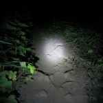
My feet crash through the branches that I am standing on and suddenly I am a foot and a half shorter. I’ve kept my balance by holding onto other branches and with a few more precarious steps I am over the huge blow-down of dead and rotting wood and trying to figure out how to get around the next obstacle. It’s the middle of the night and while I am technically ‘on a run’, my speed is sometimes negative as I backtrack and figure my way through the thick pacific northwest woods without a trail. I’m a little over 40 miles into my 75 mile journey – I had hoped to hit the bush wack section with some day light left but my pace throughout the day had been excruciatingly slow and I’ve arrived three hours after sunset.
Running an ultra is self-defining as an extreme experience; yet as we bump up against the limits we are testing – some of us look for the next thing. Now we see 200 milers and multi-day stage races, high altitude ‘sky races’, extreme heat across huge deserts, and the south pole. There is something for everyone, each thing proclaiming itself tougher and more bad ass than the next. But even as we follow this trajectory – there is a complimentary direction we can travel. What happens when the aid stations disappear? When there are no course ribbons to follow and no crew at the ready to help refill your water bottles and no way out except on your own or search and rescue? This type of adventure calls me with a louder and louder voice. Why not go out on your own or with a few friends? Explore your limits without the comfort of a organized race structure ?
Within the range of adventure runs and organized races there exist a loose collection of challenges that different people have designed and participants self-document their success or failures, adding a sort of community to what is otherwise often a very solitary pursuit. Costs are nominal to nothing, aid stations nonexistent, and there is usually no one at the finish line. The NYT recently wrote a nice piece on efforts to set FKTs (Fastest Known Times) which is another aspect that is attractive for some people; others (including me) are just in it for the challenge. Ras Vaughan launched the Ultrapedestrian.com 2014 Wilderness Challenge by having notable three endurance athletes in the pacific northwest design routes that would test the limits of participants while also rewarding them with the natural beauty of the northwest.
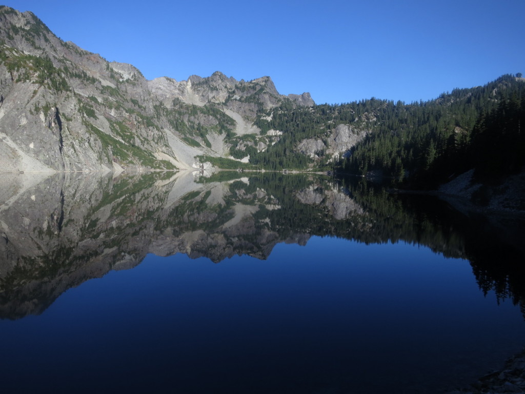
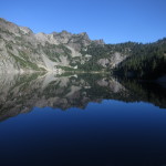
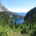
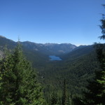
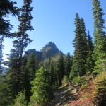
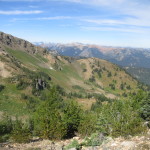
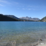
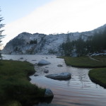
My first Alpine Lake – Snow Lake
I had friends go off and attempt these last summer, but I was worn out from the Great Himalaya Traverse and already had my own challenges and adventures line up. But I noticed from facebook posts that two friends, Heather Anderson and Adam Gaston, both very strong people (understatement) had tried the ‘Alpine Lakes’ challenge and had to quit for different reasons related to the trail (Adam’s trip report is titled ‘Epic DNF’). Stretching ~75 miles from Snoqualmie Pass to just outside Leavenworth – the route traverses remote wilderness, alpine lakes, and huge climbs that total over 22,000ft of elevation gain, with each climb getting successively harder. Even the route designer Erich Sach from the Balanced Athlete had never done the route in one continuous push – he advocated that people take several days. The original adventure challenge is a bit buried but here is the direct link to the document.
With a fresh set of challenges designed for 2015 – attention shifted toward the here and now and most of us forgot about 2014 offerings. The one exception was Christof Tseuscher, a professor from Portland who has doggedly attempted the Alpine Lakes challenge three different times only to be rebuffed by the trail. I’ve never met Christof but I am a fan from afar – his dual climb of Mt Adams and Mt Hood is enough to make my mouth drop but he also ran 158 miles between the two mountains instead of a car shuttle. over to Mt. Hood and climbs that mountain as well? The story he spun of his third attempt on the wilderness challenge made me laugh, cringe, and feel inspired.
My plan for the weekend was actually to run around Mt. Rainier on the Wonderland Trail – an adventure that has been on my list for at least five years since reading friend Adam Lint’s epic story of the circumnavigation. He ate 36 pop tarts during his run – ending with a sore mouth. There was a lot of trail wisdom out there and it was well signed and becoming a rite of passage for many. My main concern was how to drive myself back to Seattle after ~35 hours of slogging. But something in me also wanted something with a less sure outcome. I wanted the butterflies of days past. If Christof had failed three times on the Alpine Lakes Traverse maybe I would fail too. Or maybe I could learn from him and make it through? There was another calling as well. The Alpine Lakes Wilderness Area was where I found myself again in 2006 when I got off the couch and started hiking. To go back and traverse the lakes as fast as possible, all the way to Leavenworth would be bring my adventures full circle.
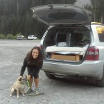
And I wasn’t alone in wanting to tackle this. Jessica Kelley (Evergreen Endurance Sports Coaching) gave me a ride to the start at Snoqualmie Pass. Her weekend was already booked, but a morning run near the pass was calling to her and giving me a ride was easily done. The first person to complete the triple crown of all three adventure challenges this summer – Jessica was no slouch. On the trip she told me that I had to succeed because the only reason shewanted to do it was because it hadn’t been completed yet. If I could finish it – she could let go and move onto other adventures. Shouldering these expectations as well as my own doubt – I shuffled away from the trail head at 6:50am on Friday morning under the watchful eyes of Jessica and her reluctant pooch.
About twenty hours later I was finally through the first bushwack. Following a real, albeit overgrown, trail I came into a giant mountain meadow under full moonlight. I cut straight across the meadow and set clouds of sleeping crickets flapping and clacking into the night air. A quick search on the far side found the trail ducking into the woods. My anxiety was still pretty high as there was a second bush whack section including a climb up to Jack Ridge. Sure enough – an hour or so later I was thrashing in the woods again – this time looking for the connector trail. But it was a much easier thrash with less deadfall and after about 20 minutes – guided partly by the glow on my gps screen and attention to the undergrowth I was back on trail climbing switch backs and watching the first streaks of light appear on the horizon. I was also 12 hours behind schedule.
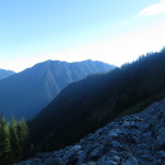
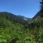
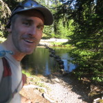
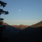
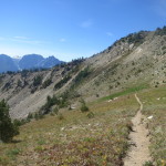
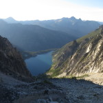
Descending WIndy Pass early afternoon
I had hoped to be starting the final climb up Aasgard Pass by dawn. This final climb was 1,900 ft feet in less than a mile – ending with a tiny drop down into high alpine bowls next to the Stewart mountain range. A truly beautiful area that is understandably called ‘The Enchantments’. It is so beautiful many of my friends visit it during the summer months as an organized 18 mile run with a car shuttle on each end. Three of my friends were due run through here starting at 9am; I had day dreams that despite my 5am start up the pass – they would catch up to me on the descent and we would run down through the lakes together jumping into random pools and rivers amidst babbling brooks filled with hoppy northwest beer. We would roll into the mountain town of Leavenworth like it had been a long day of skiing and the beer and nachos would continue to flow.
Twelve hours late, at about 5pm, there was no beer…friends…or nachos. I finally started climbing the 1,900ft up Aasgard pass. My friends had long come and gone. After a few minutes I realized my sunglasses were also gone and I spent 30 minutes back tracking amidst the boulders near the lake looking before giving up and resuming the climb. I had used them on Everest and still had the gasket that transformed them into glacier glasses. They were not cheap. I was bummed to lose them but I have long grown accustomed to losing things. You can’t tie everything to yourself right? The sun had been beating on me all day and my throat was scratched. I flopped down every few minutes – desperate for shade and to just sit and drink. I worried about heat exhaustion and remembered how I would hide in drainage pipes under highways, and in the shadows of telephone poles, while running across the great plains in 2012. Near the end, tendrils of shade reached out and gave me some reprieve. My mantra of ‘the last climb, you can finish this‘ succeeded and I found myself at the top at 7:30pm surrounded by huge alpine lakes in the upper glacial basin. In my head it was an easy 10 miles downhill to the finish, I didn’t realize I still had thousands of feet to descend and miles and miles to go. With daylight precious, I ran as fast as I could from cairn to cairn.
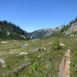
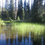
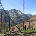
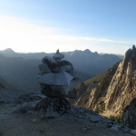
I’ve been here twice before and it just gets more beautiful
I caught a cell signal at 9pm and called Pablo who was in Leaveworth – out carousing with friends post-run. “I’m above Snow Lake!”, I said. “It’s only 3 miles from there until the end. I should be in town by 11pm. Maybe you guys will still be out partying!” I called the Leavenworth Shuttle too and arranged for a shuttle into town. They already had my credit card number on file as part of my potential bailout strategy. After an hour of descending and still not reaching Snow Lake, I finally got out my map and added up the distances – my heart sinking with each segment. I had closer to 8 miles left, big descents, and at my pace in the dark and on technical terrain with over 39 hours on my body – this would take 3-4 hours.
I ran when I could at the end. The trail was rocky and my feet hurt like you wouldn’t believe. But if there was a bit of smooth surface – I picked it up and ran. Sometime around mid-night I started mentally losing it; faces came out of the woods and later dissolved into the natural roots and rocks that they were. I felt like I was seperating into a third person – constantly chiding the runner (who was he?) to drink and continue forward. I finished at 2:54 am Sunday morning, 43:04 hours after starting. At 3:20 my much post-poned shuttle arrived and 20 minutes later I was in the lobby of the Best Western trying to stop shaking while also trying to convince the front desk clerk that I was not a homeless person and indeed my friend had a room here with an extra bed and was expecting me. Argument won, key in hand, I slipped into the hotel room to find a bag of my clean clothes in the bathroom, a hot shower, and a few minutes later…a warm bed.
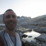
I made it! Sunday 2:53am
This was a great adventure for me. It took a lot out of me but also taught me that I can not only travel solo through the woods at night, but bushwhack to boot. It was the longest push I have ever done without sleep and ranks in my top three of overall pushes. I saw several deer, a bunny rabbit, mountain goats, and I am pretty sure a big bear (judging by its eyes and the sound it made when it crashed through the woods in the middle of the night). I saw a lot of beauty and pain and would cautiously encourage others to try this route. More notes below.
Thanks: Eric Sach (Balanced Athlete) for the challenge design (you are right, it would be better as a multi-day fast pack), Ras Vaughan and UltraPedestrian Wilderness Challenge, Jessica Kelley (Evergreen Endurance Sports Coaching) for the ride to the start, Christof Teuscher and Adam Gaston for their trail beta (I think these things get much easier as people pass on their wisdom and info – I doubt I would have finished were it not for this), Karl Helser for GPS tracks in the Enchantments, www.leavenworthshuttle.com for middle of the night trail head pickup, Pablo Cabrera, Stephanie Gundel, and Daniel Letzler for hooking me up with a place to crash when I finished in Leavenworth and a comfy car ride home.
General Gear: I used an ultraspire fastpack (weight was just under 14lbs with two liters of water), really beat up cascadia shoes, BD carbon fiber trekking poles.
Power: I knew Christof had to bail on one of his attempts because he ended up unexpectedly going into the second night but didn’t have enough batteries to light his way. So I packed a lot – and at the last minute I went and bought a cheap 2600mha cell phone emergency recharge pack (I already had a 3000mha I was carrying). Still – later in the game I worried quite a bit about keeping things charged and I often debated in my head what things to turn off.
Gadgets and guidance
I caried a finger compass as well as the Alpine Lakes Wilderness Protection Society Map (this was a really hard one to get…I don’t know if it is still available). Normally I would have cut it up and carried sections in my hand but I couldn’t do that to this map. I also had both Christof’s prior GPS tracks and map layers (Delorme and Cal Topo) loaded in various degrees on three different GPS apps. he map layers usually showed where the trail was supposed to be (in theory at least, very rarely in practice). My track was often hundreds of feet off from these peices of guidances – but they certainly helped. I carried multiple devices both as backup and also because I was curious about how they would compare (maybe another blog post someday).
Delorme Sat Transponder (Explorer) with Earthmate App installed on phone. They communicate by bluetooth. PNW map layers by Delorme were downloaded to the SD card on my phone. I had also loaded a route file into this, and people could see my location every 10 minutes online – along with my projected route. The Delorme would also allow me to trigger a search and rescue operation and communicate back and forth by text.
Backcountry Navigator Pro with Cal Topo Layers. I was running this on my phone but don’t trust it as my sole GPS app after hearing about it crashing on Julie’s Arizona adventure. Otherwise I am a fan. I would like to learn how to get the install file on a SD card so I can always restore it.
Delorme PN-60 dedicated GPS unit with the track and waypoints but no baselayers. This latter approach has been my typical practice – mostly becuase I have always been too lazy to find and install map layers.
My sat tracks can be found by adjusting the date range on https://share.delorme.com/SethWolpin to July 31st to August 2nd, a screen shot is below
Below is a simplified set of my GPS tracks (reduced to 1000 pts) – these can be downloaded. Note that my GPS died near Snow Lake – I added a way point to mark that post-trip and spliced in tracks from another source (see thanks) to reliably show the elevation profile and total distance – I did not splice in my Delorme tracks as they are at 10 minute increments and can be found online.
Light: I had a lot of lumens. A petzl Nao headlamp (300 lumen? – could be recharged off extra power banks) which I have a mixed relationship with. A relatively high end Fenix hand held (160 lumens + 1 set extra batteries), a Petzl Tikka (60 lumen? – no extra batteries).
Other: Plantronics Stereo Bluetooth headphones which I started using in 2013 on my transcon run. I love them but they only have a play time of about 7 hours. After that I didn’t bother to recharge them as music seemed like a low priority and I was too tired to mess with things.
Water: I tried to drink a ton. I carried two liter water bottles in holsters on my running pack. It was so hot on my second day (temps forecast for 100f in the enchantment basic) that my throat was constantly dry because of the dusty air, so I was always drinking. I used bleach pills from Nepal to treat about 20% of the water and drank the rest untreated. Going up through the Enchantments later on Saturday I would frequently pour water over myself to keep my temperature down. Passing any stream almost always meant dipping my hat in it and then pouring it over my head.
Food: I ate relatively nothing. I can’t explain it but I had no real appetite for most of the run. I also got sick to my stomach in the middle of the first night which is weird for me. A rough count might be 6000 calories carried and about 2000 consumed. Most of the times I tried to eat I found the food distasteful – pop-tarts are often a guilty pleasure and so are Rice Krispy Chocolate Bars from Trader Joes. Not on this trip – they are only nibbled on. The only food items I completely consumed were a small packet of peanuts, sunflower seeds, and some pacific northwest gummy bears which kept me in a pleasant state of mind.
Lessons Learned: Pack a lot of power, be ready for the bush whack, it is not a normal 75 miles, use Leavenworth shuttles as a bail out, this route is going to have some extremely overgrown sections later in the summer, be prepared for a very long haul.
I’ve been here twice before and it just gets more beautiful
I made it! Sunday 2:53am
4 thoughts on “Alpine Lakes Wilderness Challenge Report”


Nice Seth!
Hey Seth! photos are stunning. You are insane! Be safe and stay healthy! Beth
Very Cool, and Excellent work!! thanks for the plug, but more, thanks for the report.